Digital Curb Management
Urban curb space has become one of the most contested resources in modern cities, with competing demands from delivery vehicles, ride-hailing services, public transit, emergency vehicles, and traditional parking creating chronic congestion and safety hazards. The problem is particularly acute in dense urban cores, where e-commerce growth has driven a surge in commercial deliveries while ride-hailing services add thousands of additional pick-up and drop-off events daily. Traditional curb management relies on static signage and painted zones that cannot adapt to changing demand throughout the day, leading to double-parking, blocked bike lanes, and conflicts between different user groups. Digital curb management emerges as a solution to this spatial puzzle, transforming the curb from a fixed asset into a flexible, data-driven resource that can be optimized in real-time based on actual usage patterns and city priorities.
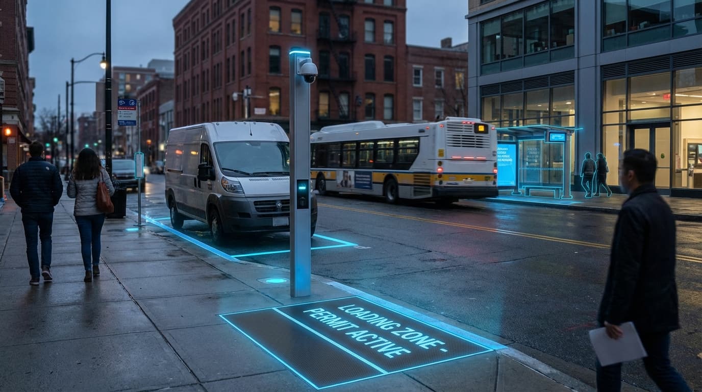
At its technical core, digital curb management systems integrate multiple data streams—including cameras, ground sensors, GPS data from vehicles, and mobile applications—to create a comprehensive, real-time picture of curb utilization. These platforms employ computer vision algorithms to detect vehicle presence and classify vehicle types, while machine learning models predict demand patterns based on historical data, weather conditions, events, and other contextual factors. The systems then enable dynamic pricing and allocation mechanisms, allowing cities to adjust curb access rules by time of day, day of week, or even in response to special events. Commercial fleet operators, delivery services, and ride-hailing drivers can reserve curb space through mobile applications, receiving precise location information and time windows for their stops. This digital layer replaces or augments traditional parking meters and static signage with dynamic digital displays that communicate current regulations, while enforcement officers receive automated alerts about violations, improving compliance without requiring constant physical monitoring.
Several major metropolitan areas have begun deploying digital curb management pilots, with early implementations demonstrating measurable reductions in dwell times, illegal parking incidents, and traffic disruptions caused by delivery vehicles circling for available space. Cities are using these platforms to prioritize curb access for electric vehicle charging during overnight hours, shift to commercial loading during morning delivery windows, and reserve space for passenger pick-ups during evening rush periods. The technology also enables new revenue models, as cities can implement demand-based pricing that charges premium rates during peak hours while offering discounted access during off-peak times. As urban logistics continue to evolve with the growth of autonomous delivery vehicles and micro-mobility options, digital curb management provides the flexible infrastructure needed to accommodate these emerging transportation modes. The broader trajectory points toward fully integrated mobility ecosystems where curb space becomes a programmable resource, dynamically allocated to maximize public benefit while supporting the complex choreography of urban movement and commerce.
Related Organizations

Develops computer vision technology that attaches to utility poles to analyze curb activity, automate payment, and enforce parking regulations.

Provides a mobility data platform for cities to manage shared mobility services and curb space digitally.

Creates a digital map of the curb (Traffic Regulation Orders) to enable dynamic parking and loading management.

Offers 'Kerb', a solution allowing delivery drivers to book guaranteed loading slots at the curb.

Municipal transportation agency that pioneered the Mobility Data Specification (MDS) and digital curb zones.

An open-source software foundation that governs the Curb Data Specification (CDS), a standard for digital curb management.

Provides overhead smart parking sensors and guidance systems to manage on-street parking and curb assets.


Provides a mobility operating system for cities, managing parking payments, enforcement, and digital curb rules.

Develops advanced computer vision API specifically optimized for reading vehicle and curb data from existing city cameras.