
Envisioning is an emerging technology research institute and advisory.

LinkedInInstagramGitHub

2011 — 2026

research
  • Reports
  • Newsletter
  • Methodology
  • Origins
  • My Collection
services
  • Research Sessions
  • Signals Workspace
  • Bespoke Projects
  • Use Cases
  • Signal Scanfree
  • Readinessfree
impact
  • ANBIMAFuture of Brazilian Capital Markets
  • IEEECharting the Energy Transition
  • Horizon 2045Future of Human and Planetary Security
  • WKOTechnology Scanning for Austria
audiences
  • Innovation
  • Strategy
  • Consultants
  • Foresight
  • Associations
  • Governments
resources
  • Pricing
  • Partners
  • How We Work
  • Data Visualization
  • Multi-Model Method
  • FAQ
  • Security & Privacy
about
  • Manifesto
  • Community
  • Events
  • Support
  • Contact
  • Login
ResearchServicesPricingPartnersAbout
  1. Home
  2. Research
  3. Wonen
  4. Omgevingsvisies (Spatial Strategy) as Constraint

Omgevingsvisies (Spatial Strategy) as Constraint

Long-range spatial strategies (national, provincial, municipal) that increasingly decide what can be built before any project enters permitting.
Back to WonenView interactive version

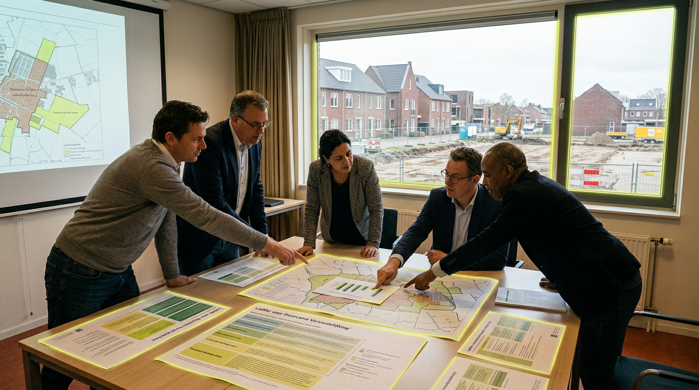
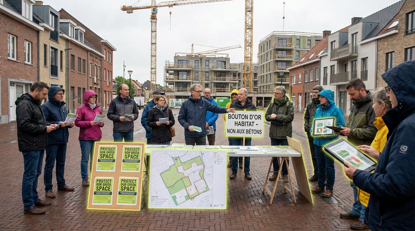
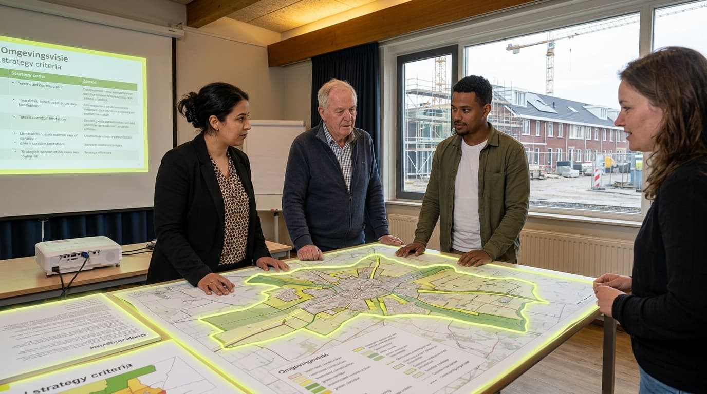
Omgevingsvisies—spatial strategies developed at national, provincial, and municipal levels—represent a fundamental shift in how development constraints are established and enforced across the Netherlands and Belgium. These long-range planning documents set binding or strongly influential direction for land use, housing growth, mobility infrastructure, climate adaptation, and nature protection, often with horizons extending ten to thirty years. The core challenge they address is the fragmentation and reactive nature of traditional permitting systems, where conflicts over density, greenfield expansion, and environmental limits emerged only after developers had invested in project design. By moving strategic choices upstream, omgevingsvisies aim to provide clarity and predictability—but in practice, they have become a new battleground where fundamental tensions between housing urgency, climate constraints, and local autonomy are fought before a single building permit is filed.

Under the logic of the Omgevingswet (Environment and Planning Act), these spatial visions function as a "pre-permitting" layer that shapes what is legally and politically feasible long before any developer submits plans. Early evidence suggests that disputes over housing density, the conversion of agricultural land, and compliance with nitrogen deposition limits or water management rules are increasingly settled at the strategy level, then defended through administrative appeals and court challenges. Municipalities that adopt restrictive visions citing biodiversity corridors or flood risk can effectively block entire categories of development, while provinces and national government may impose growth targets or infrastructure corridors that override local preferences. This creates a multi-tiered governance dynamic where alignment—or misalignment—between spatial strategies at different scales determines whether housing projects can proceed. The pattern is still emerging, but policy analysts note that the enforceability and legal weight of these visions vary significantly, with some functioning as binding frameworks and others remaining aspirational documents with limited teeth.

The implications for housing delivery and climate adaptation are profound. If omgevingsvisies succeed in integrating climate limits, infrastructure capacity, and housing targets into coherent spatial frameworks, they could accelerate permitting and reduce costly project failures. If they fail, they risk becoming another layer of complexity that delays construction and deepens conflicts between national housing goals and local resistance. Key monitoring points include the rate at which municipalities adopt actionable (rather than vague) visions, the frequency of legal challenges to strategic plans, and the degree to which public participation processes genuinely shape outcomes versus serving as procedural checkboxes. As housing pressure intensifies and climate adaptation deadlines approach, the effectiveness of omgevingsvisies as governance tools—not just planning documents—will determine whether spatial strategies enable or obstruct the transitions they are meant to guide.

Regulatory Complexity
4/5Very Complex
Community Acceptance
3/5Neutral
Social Value Generation
3/5Moderate Social Value
Category
Governance & Permitting

Related Organizations

Planbureau voor de Leefomgeving (PBL) logo
Planbureau voor de Leefomgeving (PBL)

Netherlands · Government Agency

95%

The Netherlands Environmental Assessment Agency, which conducts strategic policy analysis on housing markets and the effects of segregation/mixing.

Researcher
College van Rijksadviseurs (CRa) logo
College van Rijksadviseurs (CRa)

Netherlands · Government Agency

90%

An independent advisory board to the Dutch government on spatial quality.

Standards Body
Rho Adviseurs logo
Rho Adviseurs

Netherlands · Company

90%

A leading consultancy for spatial planning and the living environment.

Developer
Vereniging van Nederlandse Gemeenten (VNG) logo
Vereniging van Nederlandse Gemeenten (VNG)

Netherlands · Consortium

90%

The Association of Netherlands Municipalities, which coordinates the implementation of the Digital System Environment Act (DSO).

Standards Body
Antea Group logo
Antea Group

Netherlands · Company

85%

An international engineering and environmental consulting firm.

Developer
Geonovum logo
Geonovum

Netherlands · Government Agency

85%

The government organization responsible for geospatial standards in the Netherlands.

Standards Body
KuiperCompagnons logo
KuiperCompagnons

Netherlands · Company

85%

A multidisciplinary consultancy for urban planning, architecture, and landscape.

Developer
Royal HaskoningDHV logo
Royal HaskoningDHV

Netherlands · Company

85%

An independent international engineering and project management consultancy.

Developer
Tygron logo
Tygron

Netherlands · Company

85%

Develops the Tygron Geodesign Platform, which allows governments and developers to simulate and test urban plans against regulations instantly, speeding up approval.

Developer
Vereniging Deltametropool logo
Vereniging Deltametropool

Netherlands · Nonprofit

80%

An independent association focusing on the metropolitan development of the Netherlands.

Researcher

Supporting Evidence

Evidence data is not available for this technology yet.

Connections

Governance & Permitting
Omgevingswet (Environmental Law) Implementation

Netherlands' integrated environmental law consolidating 26 laws into one framework, intended to simplify and accelerate planning processes.

Regulatory Complexity
4/5
Community Acceptance
3/5
Social Value Generation
3/5
Barriers & Opposition
Watertoets (Water Assessment)

Mandatory climate adaptation assessments for development permits, increasingly restricting building in flood-prone or water-stressed areas.

Regulatory Complexity
3/5
Community Acceptance
3/5
Social Value Generation
3/5
Governance & Permitting
Woonzorgvisie (Housing-Care Vision)

Municipal strategies integrating housing planning with healthcare needs, particularly for aging populations and deinstitutionalization.

Regulatory Complexity
3/5
Community Acceptance
4/5
Social Value Generation
4/5
Governance & Permitting
Ladder voor Duurzame Verstedelijking (Ladder for Sustainable Urbanization)

Dutch sequential test requiring proof of housing need and prioritization of existing urban areas before greenfield development is permitted.

Regulatory Complexity
3/5
Community Acceptance
3/5
Social Value Generation
3/5
Barriers & Opposition
Environmental Group Opposition

Environmental organizations opposing development projects, even sustainable ones, based on habitat protection, biodiversity, or landscape concerns.

Regulatory Complexity
3/5
Community Acceptance
2/5
Social Value Generation
2/5
Governance & Permitting
Environmental Impact Assessment Processes

Comprehensive environmental review requirements that can delay projects but also identify mitigation opportunities and build legitimacy.

Regulatory Complexity
4/5
Community Acceptance
3/5
Social Value Generation
3/5

Book a research session

Bring this signal into a focused decision sprint with analyst-led framing and synthesis.
Research Sessions