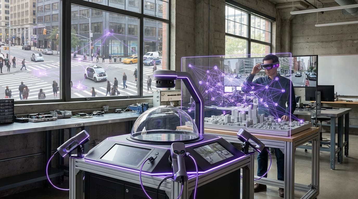
World Graph Indexing
World Graph Indexing represents a fundamental shift in how digital systems understand and interact with physical space. Unlike traditional coordinate-based mapping systems that treat locations as isolated points, this approach models the real world as an interconnected network of spatial relationships. The technology works by creating persistent digital anchors tied to physical locations, surfaces, or objects, then organizing these anchors into a queryable graph structure that captures not just where things are, but how they relate to each other. Advanced computer vision algorithms and simultaneous localization and mapping (SLAM) techniques enable devices to recognize previously mapped spaces and retrieve associated data, while graph databases maintain the complex web of spatial relationships, permissions, and metadata. This creates a shared understanding of space that persists across sessions and devices, allowing multiple users and applications to reference the same physical locations with consistent digital identities.
The core problem this technology addresses is the fragmentation and ephemerality of spatial computing experiences. Current augmented reality and location-based applications typically operate in isolation, with each app maintaining its own understanding of space that disappears when the session ends. This limitation has prevented the emergence of persistent mixed-reality experiences and collaborative spatial applications at scale. World Graph Indexing solves this by establishing a common spatial framework that applications can build upon, much like how the web's URL system allows different services to reference the same resources. Industry analysts note this capability is essential for enabling new categories of applications, from collaborative design tools that let multiple users manipulate virtual objects anchored to real spaces, to navigation systems that understand indoor environments as richly as outdoor ones. The technology also enables sophisticated permission systems, allowing property owners or administrators to control what digital content can be attached to their physical spaces.
Early deployments of world graph systems are emerging in enterprise contexts, particularly in manufacturing and logistics where persistent spatial data can guide workers through complex assembly processes or warehouse operations. Research institutions are exploring applications in cultural heritage, where historical information and reconstructions can be permanently anchored to archaeological sites or museum exhibits. The technology's trajectory suggests it will become foundational infrastructure for spatial computing platforms, similar to how mapping APIs became essential for mobile applications. As devices with spatial sensing capabilities proliferate and cloud computing resources grow more sophisticated, the vision of a comprehensive, queryable digital twin of the physical world becomes increasingly feasible. This evolution points toward a future where the boundary between physical and digital space becomes more fluid, with location-based information and experiences that persist and evolve over time rather than existing as temporary overlays.
Related Organizations
A global nonprofit working to create an open, interoperable spatial computing platform with privacy at its core.

AR platform company that develops the Lightship ARDK and owns Scaniverse, a 3D scanning app leveraging LiDAR.

Creators of CausalImpact, a package for causal inference using Bayesian structural time-series.

Provides spatial mapping and visual positioning technology that allows for city-scale AR experiences; acquired by Hexagon.

Spatial data company that integrated mobile LiDAR support into their capture app, democratizing real estate digital twins.

Provides computer vision solutions that use satellite imagery to create 3D city meshes for AR alignment.

Develops Vera, a computer vision platform that digitizes physical buildings into an intelligent 3D digital twin.


A leading Korean AR company providing a VPS SDK for city-scale spatial recognition.

Japanese startup developing the '3D Scanner App' and AR cloud platform to enable multiplayer, persistent AR entertainment.