Cultural Heritage Preservation
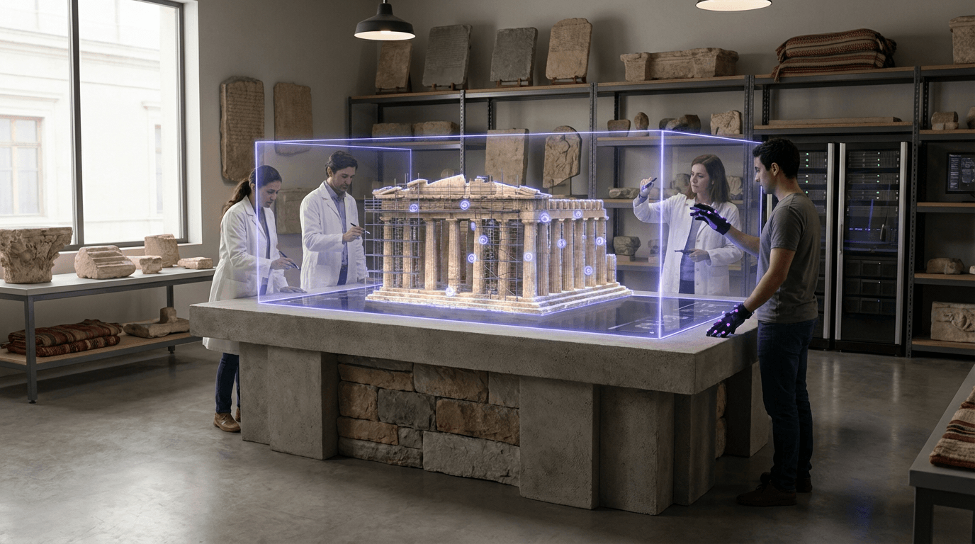
Cultural heritage preservation through spatial computing represents a critical response to the accelerating loss of irreplaceable cultural sites, artifacts, and practices worldwide. This technology employs high-resolution 3D scanning, photogrammetry, LiDAR mapping, and volumetric capture to create detailed digital replicas of physical spaces, objects, and even intangible cultural practices like traditional ceremonies or craft techniques. The process typically involves deploying arrays of cameras and sensors to capture spatial data from multiple angles, which sophisticated algorithms then process into immersive three-dimensional models. These digital archives go beyond simple photographs or video recordings by preserving the precise spatial relationships, textures, and scale of heritage sites, allowing users to navigate and examine them as if physically present. Advanced implementations incorporate spectral imaging to capture details invisible to the human eye, such as underlying paint layers in ancient murals or structural weaknesses in aging monuments, while temporal capture techniques can document seasonal rituals or environmental changes over time.
The urgency driving adoption of these preservation methods stems from multiple converging threats to cultural heritage. Rising sea levels endanger coastal archaeological sites and island communities, while extreme weather events accelerate the deterioration of ancient structures never designed to withstand such conditions. Armed conflicts continue to result in deliberate destruction of heritage sites, as witnessed in recent decades across the Middle East and other regions. Urban development pressures force difficult choices between preservation and modernisation, particularly in rapidly growing cities where ancient neighborhoods face demolition. Traditional knowledge systems and ceremonial practices face extinction as elder practitioners pass away without successors, creating an intangible heritage crisis alongside physical losses. Spatial preservation technologies address these challenges by creating permanent records that survive physical destruction, enable remote access when sites become dangerous or inaccessible, and provide educational resources that can inspire new generations to value and continue cultural traditions. Museums and cultural institutions increasingly recognise that digital preservation complements rather than replaces physical conservation, offering insurance against catastrophic loss while democratising access to heritage previously available only to those who could travel to specific locations.
Current deployments demonstrate the technology's versatility across diverse cultural contexts. Indigenous communities in the Arctic are documenting traditional territories and seasonal camps threatened by permafrost melt, creating spatial archives that preserve not just physical structures but also the cultural knowledge embedded in landscape relationships. Archaeological teams have captured detailed scans of sites in conflict zones, enabling continued research even when physical access becomes impossible and providing blueprints for potential reconstruction efforts. Major museums now offer virtual reality experiences that transport visitors inside tombs, temples, and ceremonial spaces too fragile for mass tourism, while educational institutions use these resources to provide students with experiential learning opportunities previously limited to expensive field trips. The technology also supports cultural revitalisation efforts, as diaspora communities use spatial archives to maintain connections with ancestral homelands and younger generations explore heritage sites their elders can no longer physically visit. As climate change and geopolitical instability continue to threaten cultural heritage globally, spatial preservation technologies are evolving from experimental projects into essential infrastructure for cultural continuity, ensuring that future generations can experience and learn from humanity's diverse heritage even as physical sites face unprecedented challenges.
Related Organizations

A nonprofit dedicated to digitally recording, archiving, and sharing the world's most significant cultural heritage sites.

French startup specializing in the digitization of endangered cultural heritage sites using drones and 3D photogrammetry.
Organization dedicated to the digital preservation of art and artifacts, developing custom high-res scanners.

Platform providing virtual tours of museums, heritage sites, and landmarks using Street View technology.

World's largest museum complex, actively digitizing collections for virtual tours.

A research center at Carleton University dedicated to the advanced geometric modelling and digital representation of architecture.

A 3D asset platform (owned by Epic Games) that hosts a massive library of cultural heritage scans from museums worldwide.

The UN agency responsible for the 'Recommendation on the Ethics of Artificial Intelligence'.

Software company (acquired by Epic Games) providing photogrammetry tools used extensively for heritage preservation.
The British Museum
United Kingdom · Nonprofit
Major public museum actively digitizing its collection and experimenting with VR tours and AR guides.