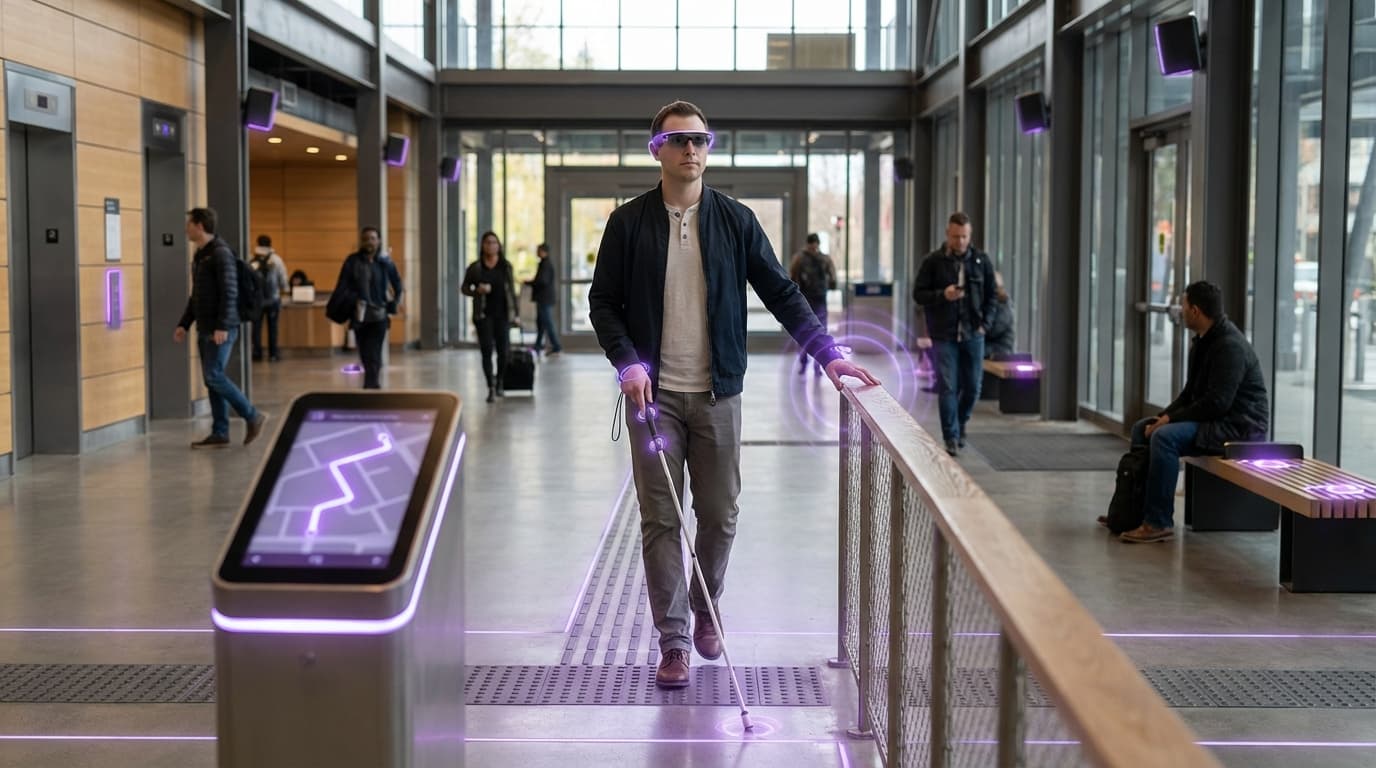
Assistive Spatial Navigation
Assistive spatial navigation represents a convergence of extended reality (XR) technologies, computer vision, and multimodal feedback systems designed to address the profound mobility and orientation challenges faced by individuals with visual impairments or physical disabilities. Traditional navigation aids like white canes and guide dogs, while valuable, offer limited information about the surrounding environment and cannot dynamically adapt to complex or changing spaces. This technology leverages spatial computing capabilities—including depth sensing, real-time object recognition, and environmental mapping—to create a comprehensive understanding of physical spaces. Through wearable devices such as smart glasses, haptic vests, or bone-conduction headphones, the system translates visual and spatial information into accessible formats. Spatial audio provides directional cues that indicate the location of obstacles, doorways, or points of interest, while haptic feedback patterns communicate proximity warnings or surface characteristics through vibrations. Advanced implementations incorporate machine learning algorithms to classify objects, read signage, recognize faces, and even interpret social cues like whether someone is facing the user or gesturing.
The fundamental challenge this technology addresses is the information asymmetry that exists in environments designed primarily for sighted, fully mobile individuals. Public spaces, transportation systems, and commercial buildings often lack adequate accessibility features, forcing people with disabilities to rely on incomplete mental maps or the assistance of others. Assistive spatial navigation systems overcome these limitations by providing real-time, context-aware guidance that adapts to each user's specific needs and preferences. For individuals with low vision, the system can enhance contrast, highlight edges, or magnify specific areas of interest. For those who are completely blind, it translates the visual world into rich auditory and tactile landscapes. The technology also addresses cognitive load concerns by filtering and prioritizing information, presenting only the most relevant environmental details to prevent sensory overload. This selective attention mechanism ensures users receive actionable guidance without being overwhelmed by constant feedback about every object in their vicinity.
Early deployments of assistive spatial navigation systems have emerged from both academic research labs and specialized accessibility technology companies, with pilot programs conducted in controlled environments like university campuses, museums, and transit stations. These implementations demonstrate significant improvements in user confidence, navigation speed, and independent mobility compared to traditional aids alone. The technology is particularly transformative in unfamiliar environments where users lack established mental maps, enabling spontaneous exploration rather than requiring extensive pre-planning or memorization of routes. As spatial computing infrastructure becomes more prevalent in smart cities—with buildings and public spaces increasingly equipped with digital twins and location-aware services—assistive navigation systems will be able to access richer environmental data, including real-time updates about temporary obstacles, crowd density, or service disruptions. This evolution aligns with broader movements toward universal design and inclusive urban planning, where accessibility features benefit not only people with disabilities but all users navigating complex environments. The integration of these systems with emerging standards for accessible digital infrastructure suggests a future where physical spaces become inherently more navigable and inclusive, fundamentally reshaping the relationship between individuals with disabilities and their built environment.
Related Organizations

Provides camera-based indoor navigation for the blind using LiDAR scanning and image recognition to create accessible digital maps.

Develops long-range high-density visual markers to help visually impaired people navigate urban spaces like subway stations and bus stops.

Develops AI-powered smart glasses (based on Google Glass Enterprise Edition 2 hardware) that speak out what the user is looking at.

Through Copilot and the 'Recall' feature in Windows, Microsoft is integrating persistent memory and agentic capabilities directly into the operating system.

Produces a smart white cane that detects overhead obstacles via ultrasound and integrates with smartphone navigation apps.

An intelligent guide app for the blind and visually impaired that provides real-time audio messages about the user's surroundings.

Provides highly accurate indoor and outdoor navigation for visually impaired users without relying on GPS or physical beacons.

Connects people who are blind or low vision to remote human agents who use the user's camera to provide visual interpretation and navigation.

Developing 'Apple Intelligence', a personal intelligence system integrated into iOS/macOS that uses on-device context to mediate tasks and information.