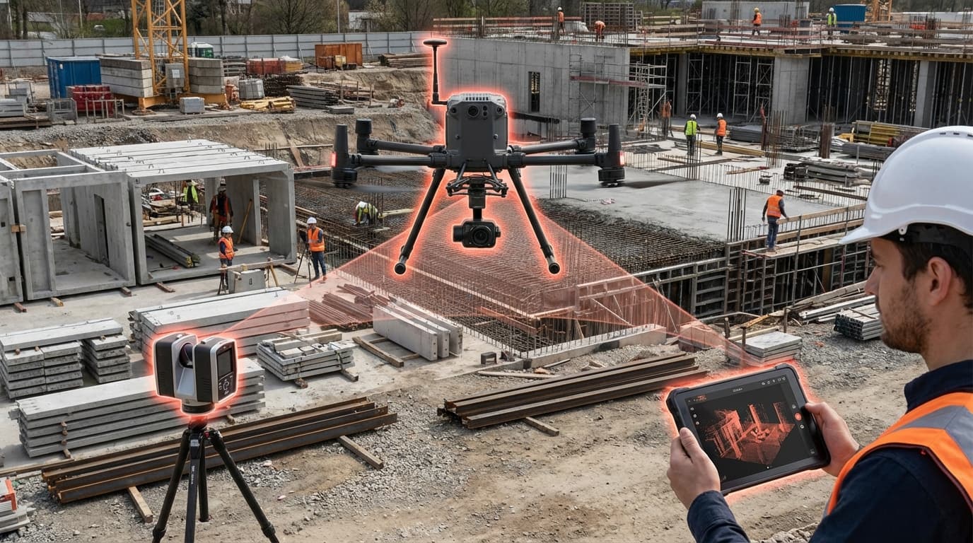
UAV LiDAR & Reality Capture
The construction industry has long grappled with the challenge of accurately capturing existing site conditions and monitoring project progress across large, complex work sites. Traditional surveying methods, while precise, are time-consuming, labor-intensive, and often require physical access to hazardous or difficult-to-reach areas. UAV LiDAR and reality capture technologies address these limitations by deploying unmanned aerial vehicles equipped with Light Detection and Ranging sensors, high-resolution cameras, or both, alongside ground-based mobile scanning systems. These platforms rapidly collect millions of spatial data points, creating dense three-dimensional point clouds that represent the physical environment with millimeter-level accuracy. LiDAR works by emitting laser pulses and measuring their return time to calculate distances, while photogrammetry derives spatial information from overlapping photographs. The resulting datasets can be processed into various outputs including orthomosaic maps, digital elevation models, and textured 3D meshes that serve as digital twins of construction sites.
For construction firms, this technology fundamentally transforms how projects are documented, measured, and managed throughout their lifecycle. Site surveys that once required days or weeks of field work can now be completed in hours, with drones covering hundreds of acres in a single flight session. This efficiency enables more frequent progress monitoring, allowing project managers to verify that work matches design specifications, measure earthwork volumes for payment applications, and detect deviations or conflicts before they escalate into costly rework. The technology also enhances safety by reducing the need for personnel to access active construction zones or unstable terrain for measurement purposes. Beyond initial site surveys, reality capture supports clash detection when point cloud data is compared against Building Information Models, facilitates accurate as-built documentation for facility management, and provides verifiable records for dispute resolution. The shift from periodic manual surveys to continuous digital monitoring represents a fundamental change in how construction projects maintain spatial accuracy and accountability.
Early adoption has been strongest in civil infrastructure projects, mining operations, and large commercial developments where the scale of work justifies the technology investment. Construction companies are increasingly integrating reality capture into standard workflows, with some major contractors conducting weekly or even daily drone flights on active projects. The data collected feeds directly into project management platforms and BIM software, creating feedback loops that tighten the connection between design intent and field execution. As sensor costs decline and processing algorithms become more automated, the technology is extending beyond large contractors to mid-sized firms and specialty trades. This democratization aligns with broader industry trends toward digitalization and data-driven decision-making, positioning reality capture as essential infrastructure for the construction sector's ongoing transformation toward greater precision, efficiency, and transparency in how the built environment is created and maintained.
Related Organizations

Leica Geosystems
Switzerland · Company
A premium manufacturer of measurement and survey equipment, including airborne and terrestrial LiDAR.

Provider of mobile mapping systems and reality capture software for indoor spatial intelligence.

US drone manufacturer specializing in autonomous flight and 3D scan software.

Cloud software platform for commercial drones, enabling aerial mapping and 3D modeling of construction sites.

Creators of Hovermap, a LiDAR mapping payload that enables autonomous drone flight in GPS-denied environments.

Develops photogrammetry software to convert drone images into 3D models and maps.

Provides a cloud platform for processing drone survey data and 'AeroPoints' for ground control.

Spun out of UPenn's GRASP Lab, developing Level 4 autonomous aerial robot systems for mapping complex, GPS-denied environments like mines.

Develops 'drone-in-a-box' solutions for autonomous industrial and urban monitoring.

Manufactures VTOL (Vertical Take-Off and Landing) mapping drones for surveying.