Humanitarian Corridors & Protected Zone Management
In conflict zones, the establishment and maintenance of humanitarian corridors and protected zones represents one of the most critical yet challenging aspects of modern warfare and crisis response. These designated safe passages and areas are intended to allow civilians to evacuate danger zones, enable humanitarian aid delivery, and provide sanctuary for vulnerable populations. However, traditional methods of designating and monitoring these zones have relied heavily on manual coordination, paper agreements, and limited verification capabilities, making them vulnerable to violations and difficult to enforce in real-time. The fundamental challenge lies in creating a reliable system that can rapidly establish protected areas, continuously verify compliance by all parties, and provide actionable intelligence when violations occur—all while operating in the chaotic, dynamic environment of active conflict.
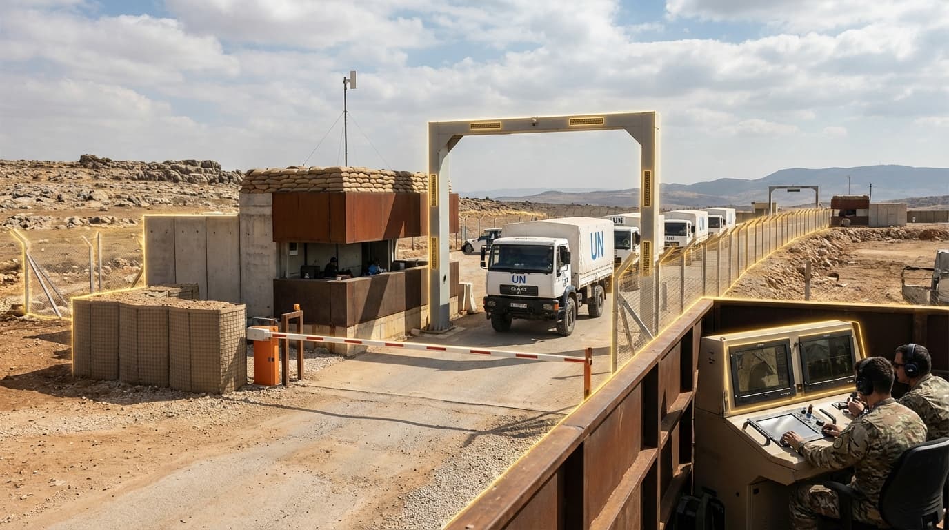
Modern humanitarian corridor management systems integrate multiple defense and intelligence technologies into unified platforms designed specifically for civilian protection operations. At their core, these systems employ intelligence, surveillance, and reconnaissance (ISR) assets—including satellite imagery, aerial drones, and ground-based sensors—to maintain continuous monitoring of designated protected zones. Secure communication networks enable real-time coordination between military forces, humanitarian organisations, and international observers, ensuring all parties maintain awareness of corridor status and any emerging threats. Advanced artificial intelligence algorithms process incoming sensor data to detect potential violations, such as unauthorised military movements into protected areas, weapons fire near safe zones, or obstructions to aid convoys. These AI systems can distinguish between legitimate activity and potential breaches of international humanitarian law, automatically alerting relevant authorities and generating evidence documentation. The platforms also incorporate geofencing capabilities that can trigger warnings when military assets approach protected boundaries, and some systems integrate with command and control networks to enable rapid response when civilian safety is threatened.
Several international organisations and national defense agencies have begun deploying early versions of these integrated protection systems in recent conflict zones, though widespread adoption remains limited by political, technical, and operational challenges. Research suggests that AI-assisted monitoring can significantly reduce response times to corridor violations and improve evidence collection for potential war crimes investigations. The technology shows particular promise in complex urban warfare environments where traditional monitoring methods struggle to maintain situational awareness. As conflicts increasingly occur in densely populated areas and the international community places greater emphasis on civilian protection, these systems represent a crucial evolution in how military capabilities can be redirected toward humanitarian objectives. The integration of defense technologies with humanitarian law frameworks points toward a future where protected zone management becomes more transparent, verifiable, and enforceable, potentially saving countless civilian lives in future conflicts.
Related Organizations
Humanitarian institution based in Geneva.

United States · Government Agency
Coordinates global emergency response and manages the Humanitarian Data Exchange (HDX) to map and monitor safe zones.

Develops advanced warning systems and predictive analytics to protect civilians and humanitarian assets in conflict zones.
Works with armed actors and civilians to develop protection strategies and policies.

Academic research center focusing on the use of satellite imagery and remote sensing to monitor human rights and conflict zones.

Provides high-resolution Earth imagery and geospatial analytics.

Interdisciplinary practice using spatial analysis and architectural reconstruction to document human rights violations.
Uses open-source intelligence (OSINT) and satellite imagery to verify attacks on civilians in designated safe areas.

Crowdsourcing platform that collects ground-level data to verify conditions in hard-to-reach areas.

Technology leader in the development of open-source software for information collection, visualization, and interactive mapping.
Supporting Evidence
Research this in Signals
Signals turns a topic into a sourced research record you can inspect and rerun. Your first scan is free, and this one starts with Humanitarian Corridors & Protected Zone Management already loaded, so edit it or scan as is.