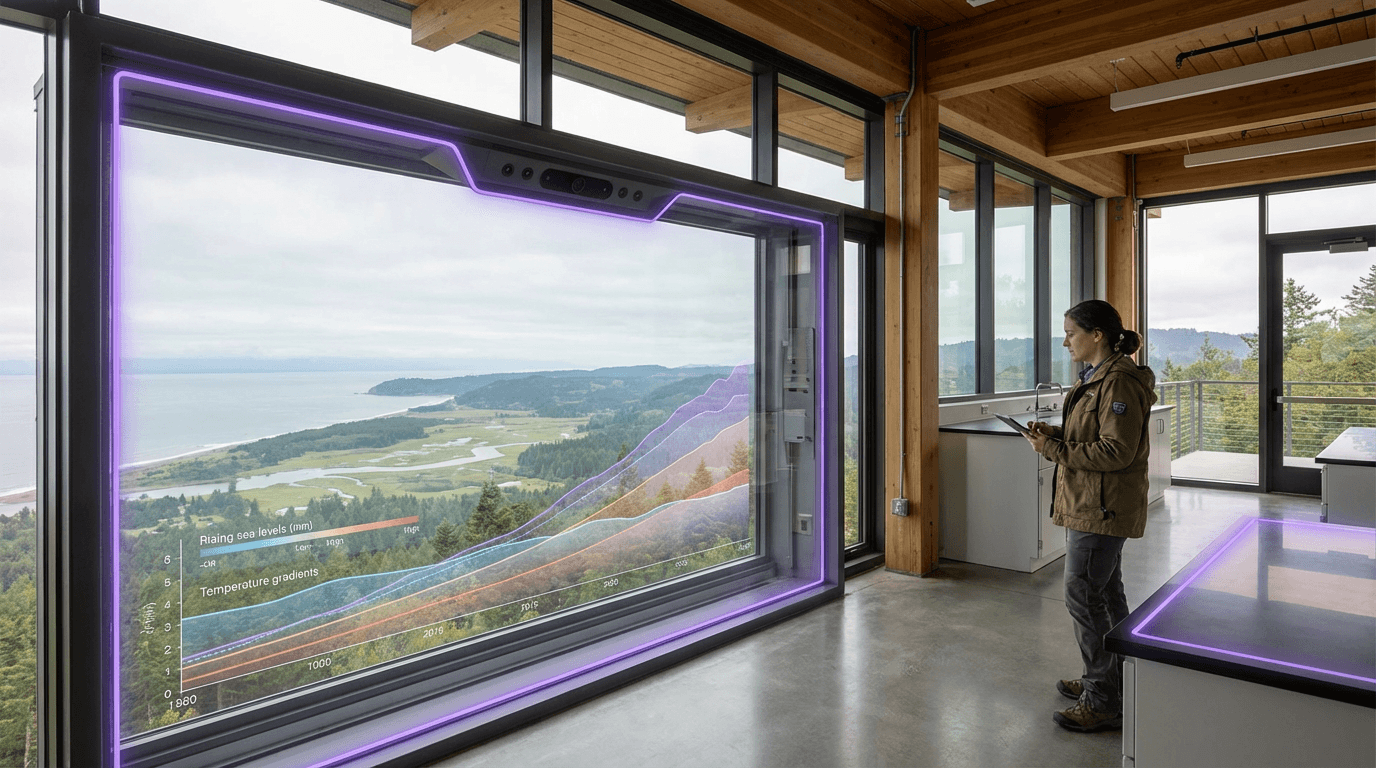
Climate Visualization Layers
Climate visualization layers represent a convergence of augmented reality technology and environmental data science, enabling users to perceive and interact with otherwise invisible climate phenomena in their immediate surroundings. The technology operates by integrating real-time environmental sensor data, historical climate records, and predictive modeling outputs with spatial computing systems that anchor digital information to specific geographic locations. Through AR-enabled devices such as smartphones, tablets, or head-mounted displays, users can view overlays that render abstract climate data as visible, contextually-relevant information superimposed onto the physical landscape. The underlying architecture typically combines geographic information systems (GIS), atmospheric modeling software, and computer vision algorithms that track the user's position and orientation to maintain accurate alignment between digital overlays and real-world features. These systems can visualize diverse environmental parameters including particulate matter concentrations, projected flood zones, temperature anomalies, carbon dioxide levels, and temporal comparisons showing how specific locations have changed or may change under various climate scenarios.
The fundamental challenge this technology addresses is the psychological and perceptual distance that often separates people from climate change impacts. Abstract statistics, global temperature averages, and distant projections frequently fail to motivate behavioral change or policy action because they lack immediate, personal relevance. By translating complex environmental datasets into spatially-anchored visual experiences, climate visualization layers transform abstract threats into concrete, localized realities that viewers can witness in familiar settings. Urban planners can use these tools to communicate the implications of development decisions, showing stakeholders how proposed buildings might affect local heat islands or how green infrastructure could mitigate flooding risks. Environmental educators employ these visualizations to help students understand ecosystem dynamics and human impacts in their own neighborhoods rather than through distant examples. Policy advocates have found these immersive demonstrations particularly effective in public engagement, as seeing one's own street submerged under projected sea level rise or viewing historical air quality degradation in a familiar park creates emotional resonance that traditional presentations cannot match.
Early implementations have appeared in coastal cities where sea level rise visualization has supported infrastructure planning discussions, and in urban centers where air quality overlays help residents make informed decisions about outdoor activities. Museums and science centers have deployed these systems as educational exhibits, while some municipalities have begun integrating climate visualization capabilities into public planning processes. Research suggests that experiencing climate data in this spatially-grounded manner significantly increases both comprehension and concern compared to conventional data presentation methods. As climate modeling becomes more granular and AR devices more ubiquitous, these visualization layers are positioned to become standard tools in environmental communication, urban resilience planning, and public education. The technology aligns with broader movements toward data democratization and participatory planning, offering a pathway to make climate science more accessible and actionable for diverse audiences who will ultimately need to adapt to environmental changes in their specific locations.
Related Organizations

Science and news organization providing open tools like Surging Seas to visualize sea-level rise impact.

Global leader in GIS software (ArcGIS), providing the spatial analytics layer used by thousands of local governments for urban planning and policy.

Developed and operates the EMIT (Earth Surface Mineral Dust Source Investigation) hyperspectral instrument on the ISS.

Offers free, interactive climate maps and data to help communities and businesses understand local climate risks.

Arup
United Kingdom · Company
A multinational professional services firm dedicated to sustainable development, known for pioneering the use of BIM in complex engineering projects.

An immersive data visualization company that allows users to 'step inside' data, including environmental and geospatial datasets.

Creators of CausalImpact, a package for causal inference using Bayesian structural time-series.

Home of the Affective Computing research group led by Rosalind Picard.

Owner of the Arnold renderer, which integrates AI denoising to optimize high-end VFX workflows for film and TV.

Social media and camera company developing AR spectacles.