AR Urban Planning
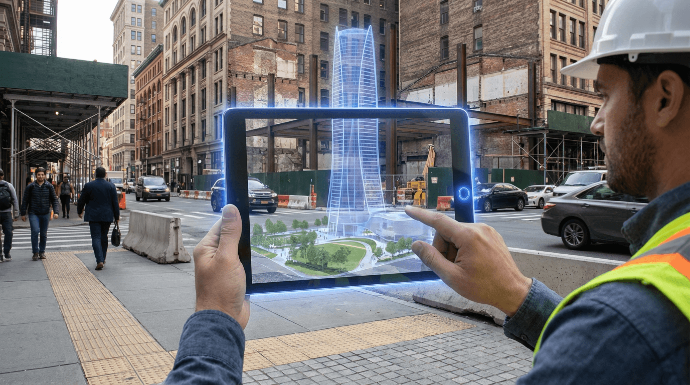
Augmented reality urban planning represents a paradigm shift in how cities conceptualize and communicate development proposals. Unlike traditional methods that rely on two-dimensional blueprints, scale models, or computer renderings viewed on screens, AR technology enables stakeholders to experience proposed infrastructure at full scale within its actual future location. The system works by combining real-time camera feeds from smartphones, tablets, or AR headsets with precise geospatial data and three-dimensional building models. Through computer vision algorithms and GPS positioning, these applications anchor virtual structures to specific coordinates in the physical world, allowing users to walk around, through, and alongside proposed developments as if they already existed. This spatial anchoring creates an intuitive understanding of scale, massing, and contextual relationships that is impossible to achieve through conventional visualization methods.
The fundamental challenge this technology addresses is the persistent disconnect between how urban development is planned and how it is ultimately experienced by those who live with its consequences. Traditional public consultation processes often struggle to convey the true impact of proposed projects, leading to community opposition rooted in misunderstanding or decisions made without full appreciation of spatial implications. AR urban planning bridges this gap by transforming abstract proposals into tangible, experiential previews. Citizens can stand at street level and see exactly how a new building will affect sunlight in a public park, whether a proposed tower will obstruct cherished views, or how a redesigned intersection will alter pedestrian flows. This immediacy of understanding fundamentally democratizes the planning process, giving voice to stakeholders who may lack the technical literacy to interpret conventional architectural drawings. For developers and municipal planners, the technology reduces costly design revisions by identifying conflicts and concerns earlier in the development cycle, when changes are still feasible and affordable.
Early implementations of AR urban planning tools have emerged in several forward-thinking municipalities, with pilot programs demonstrating significant improvements in public engagement metrics and stakeholder satisfaction. Some planning departments now conduct on-site AR demonstrations during community meetings, allowing residents to experience proposals in context rather than viewing them in sterile conference rooms. The technology has proven particularly valuable for complex infrastructure projects such as transit corridors, pedestrian bridges, and mixed-use developments where spatial relationships are critical to public acceptance. As AR hardware becomes more accessible and 5G networks enable real-time rendering of increasingly detailed models, this approach is positioned to become standard practice in urban development. The convergence of AR urban planning with digital twin technologies and participatory design platforms suggests a future where cities evolve through continuous, spatially-informed dialogue between planners and communities, creating built environments that more accurately reflect collective values and needs.
Related Organizations

Develops Tekla Structures, a leading BIM software for structural engineering and steel detailing, along with hardware for connecting BIM to the field.

Provides an AR platform that visualizes GIS, BIM, and laser scan data on-site for utilities and municipalities.

Global leader in GIS software (ArcGIS), providing the spatial analytics layer used by thousands of local governments for urban planning and policy.

Creates 3D digital twins and AR visualizations specifically for communicating urban projects to stakeholders.

Creators of 'The Atom', an engineering-grade AR headset designed specifically for construction accuracy.


AR platform company that develops the Lightship ARDK and owns Scaniverse, a 3D scanning app leveraging LiDAR.

AR headset manufacturer utilizing dynamic dimming and eye-tracking for optimized rendering.