Reality Capture & 4D/5D BIM
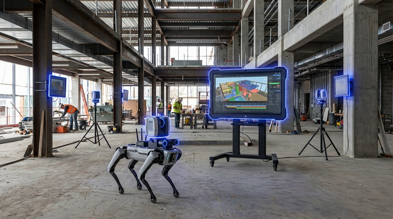
Reality Capture and 4D/5D BIM represents a fundamental shift in how construction projects are monitored, documented, and managed throughout their lifecycle. Traditional construction oversight has relied on manual inspections, periodic site visits, and static two-dimensional drawings that quickly become outdated as work progresses. This approach creates information gaps between design intent and actual construction, leading to costly rework, schedule delays, and disputes over project milestones. Reality capture technologies—including drone photogrammetry, mobile LiDAR scanning, and 360-degree imaging—now enable continuous digital documentation of construction sites, capturing millions of spatial data points that represent the physical state of a project at any given moment. When this captured data is integrated with Building Information Modeling (BIM) that incorporates time (4D) and cost (5D) dimensions, project teams gain unprecedented visibility into how construction is actually unfolding compared to original plans and budgets.
The construction industry has long struggled with the disconnect between design models and field conditions, a gap that often remains invisible until problems become expensive to fix. Reality capture workflows address this challenge by creating a continuous feedback loop between the physical site and digital models. As drones and scanning equipment traverse active construction zones—sometimes on daily or weekly schedules—they generate point clouds and imagery that can be automatically compared against the BIM model. Sophisticated algorithms detect geometric deviations, identify elements that should have been installed but are missing, and flag components that appear ahead of or behind schedule. When linked to 4D scheduling data, these comparisons reveal whether the project is tracking to its timeline, while 5D cost integration allows for automated progress verification that can trigger milestone payments based on actual completed work rather than subjective assessments. This capability transforms project controls from reactive problem-solving into proactive risk management, enabling teams to identify clashes, coordinate trades more effectively, and maintain tighter control over budgets.
Early adopters in large-scale infrastructure and commercial construction have demonstrated the value of these integrated workflows, with some projects reporting significant reductions in rework and schedule overruns. The technology proves particularly valuable on complex projects where coordination between multiple trades is critical, or where remote stakeholders need reliable progress updates without constant site visits. As scanning hardware becomes more affordable and cloud-based platforms simplify data processing, reality capture is moving beyond mega-projects into mid-sized developments and renovation work. The convergence of these technologies with artificial intelligence and machine learning promises even greater automation, with systems that can predict potential issues before they manifest and recommend corrective actions based on patterns detected across multiple projects. This evolution positions reality capture and dimensional BIM as essential infrastructure for the construction industry's digital transformation, supporting the shift toward more predictable, efficient, and transparent project delivery in an era where margins are tight and stakeholder expectations for accountability continue to rise.
Related Organizations

AI-powered platform that maps 360° video to floor plans for automated construction documentation.
Visual command center for construction that overlays reality capture on BIM and schedule.


Global leader in 3D measurement, imaging, and realization technology.

Hexagon AB
Sweden · Company
A global leader in sensor, software, and autonomous solutions, providing reality capture for digital twins.

Platform automating construction quality monitoring using 3D scanning and AI.

Develops Tekla Structures, a leading BIM software for structural engineering and steel detailing, along with hardware for connecting BIM to the field.

Cloud software platform for commercial drones, enabling aerial mapping and 3D modeling of construction sites.

Provider of mobile mapping systems and reality capture software for indoor spatial intelligence.