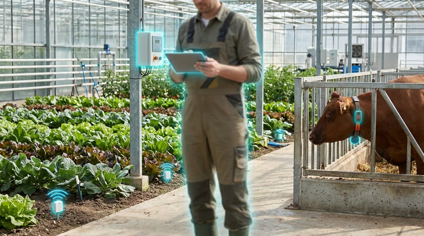
Precision Agriculture & Livestock Monitoring
Modern agriculture faces mounting pressure to feed a growing global population while contending with climate variability, water scarcity, and the need to reduce environmental impact. Traditional farming methods often rely on uniform treatment of entire fields and reactive approaches to livestock health, leading to inefficient resource use, crop losses, and animal welfare concerns. Precision agriculture and livestock monitoring address these challenges through networks of interconnected sensors, imaging systems, and automated equipment that enable farmers to make data-driven decisions at unprecedented granularity. By deploying soil moisture sensors, weather stations, drone-mounted multispectral cameras, and GPS-guided machinery across farmland, alongside wearable devices that track vital signs and behavior patterns in livestock, this approach transforms agriculture from a practice of averages into one of targeted interventions tailored to the specific needs of individual plants, field zones, or animals.
The technical foundation of these systems relies on diverse connectivity solutions adapted to the unique constraints of agricultural environments. In remote farming regions where traditional cellular coverage is absent, Low Power Wide Area Networks (LPWAN) such as LoRa and NB-IoT provide the backbone for transmitting sensor data across vast distances while consuming minimal power, allowing battery-operated devices to function for years without replacement. Satellite connectivity fills remaining coverage gaps, ensuring that even the most isolated operations can participate in data-driven farming. Edge computing devices process streams of information locally, identifying patterns such as early disease indicators in crops or signs of distress in cattle, while cloud platforms aggregate data across seasons to reveal longer-term trends and optimize planting strategies. Machine learning algorithms analyze multispectral imagery to detect nutrient deficiencies invisible to the human eye, calculate precise irrigation requirements down to individual field sections, and predict optimal harvest timing based on weather forecasts and crop maturity indicators.
Commercial adoption of these technologies has accelerated significantly in recent years, with systems now deployed across operations ranging from family farms to large-scale agricultural enterprises. Variable-rate irrigation systems adjust water delivery in real-time based on soil moisture readings and weather predictions, reducing water consumption while maintaining or improving yields. Autonomous tractors equipped with computer vision navigate fields with centimeter-level precision, applying fertilizers and pesticides only where needed rather than broadcasting them uniformly. Livestock wearables monitor rumination patterns, activity levels, and body temperature to detect illness days before visible symptoms appear, enabling early intervention that improves animal welfare and reduces antibiotic use. As climate change intensifies pressure on agricultural systems and global food demand continues rising, these precision farming technologies represent a critical pathway toward sustainable intensification—producing more food with fewer inputs while minimizing environmental degradation and enhancing resilience to increasingly unpredictable growing conditions.
Related Organizations

Creates solar-powered GPS collars that enable virtual fencing (herding cows via sound/vibration) alongside health monitoring.
A global machinery giant that operates the Operations Center, one of the largest repositories of agronomic and machine data in the world.

Global leader in livestock identification and monitoring systems (part of MSD Animal Health).

Provides a farm management system integrated with proprietary soil sensors for moisture, temperature, and EC.

Develops Tekla Structures, a leading BIM software for structural engineering and steel detailing, along with hardware for connecting BIM to the field.

A top-tier university for agricultural research, specifically in greenhouse and vertical farming innovation.

Operates 'Community Notes' (formerly Birdwatch), the most prominent collaborative verification system at scale.
Provides aerial spectral imagery analytics to detect irrigation issues and disease pressure.

Uses sub-millimeter aerial imagery and AI to detect crop diseases and pests at leaf-level resolution.

Semiconductor supplier and developer of the LoRaWAN protocol.